Map References

War Office Cassini Grid
We have been asked a number of times about the Map References quoted, the answer is the sytem used was the War Office Cassini Grid which was introduced in 1927. It was used by the Army and RAF throughout the second world war:
As you will have noticed the actual map references only use one letter this is we believe because all of the V2’s landed in the area covered by the lowercase ‘w’.
If you wish to convert any of the quoted references to co-ordinates that can be entered into Google Maps etc please try this site that we are using to convert to co-ordinates we need to produce the maps on our site: FieldenMaps
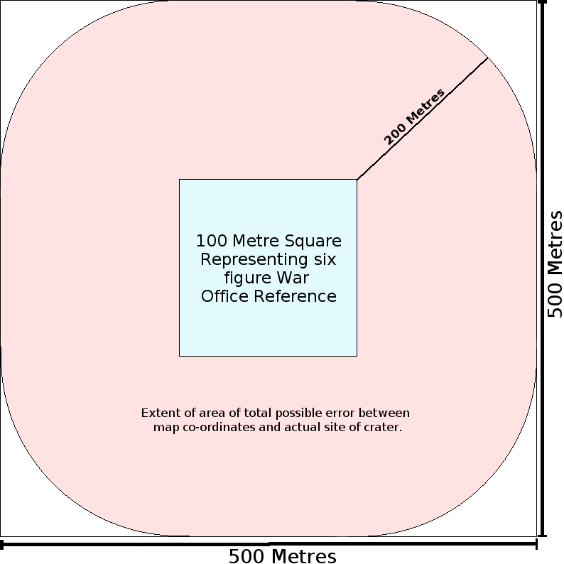
Extent of Possible Map Errors
You should also bear in mind when checking the plots on a map that the 6-figure War Office map references represents a 100 metre square and as far as we can tell the best we can hope for is a +- 200 metres accuracy in converting this reference to current co-ordinates that can be entered into Google Maps so it is our guess that the exact position of the original crater would have been some where in the highlighted area represented in the diagram on the left.
Hi
This ref Number (Sheet 31/690365) refers to a Flying Bomb Impact on 24/12/1944 in Grange Moor Wakefield, now new houses I am trying to locate its exact location.
Thank You.
No V2 incident is recorded this far North we suggest it was a V1 so we have no information.
Incident Number 23 – V2 Position and Crater
Hi thank you for a superb website which feeds my lifelong fascination with anything to do with WW2. I will like to ask about incident 23 in Hockley Essex, where I have lived the bulk of my life. I believe the site for this is actually in the square woods to the east of its current marked position in Marylands Woods, bordering Mount Crescent, just the other side of the railway crossing. There is a huge crater, filled with water within the south east corner of these woods
Please take note of the information at the top of this page.
Great website, very interesing, thank you.
Could you please give an example or a few further clues as to how to convert the Cassini Coordinates to Lat & Long please?
Looking at the second V2 from the 8th of Sept 1944 it gives the Ref as L 892 254 and using the website suggested the best I can do is to place it somewhere in the North Sea about 42 miles west of the Danish coast! Whearas it should be Nr Epping.
I have tried many permutation without sucess, any help much appreciated, thanks.
Regards
Mike
Quite late to the discussion, and most likely you have found your answer by now, but in any case for future reference, here’s a great site:
https://www.echodelta.net/mbs/eng-welcome.php
There they have a very user friendly “Coordinates Translator” where you choose your appropriate grid from the drop down menu (note: the British Cassini Grid is default), then enter your modified British System coordinates to be decoded and will spit out the exact latitude/longitude which you can then plug in to the on line mapping application of your choice. To your specific question, the British Cassini Grid coordinates of xL 892 254 translates to the following lat/lon, just on the southern outskirts of the town of Harlow, north of London.
51° 44′ 16” N, 0° 05′ 39” E